

چکیده مطلب
اصول سیستم اطلاعات جغرافیایی
مخاطب گرامی : متن حاضر نوشتاری است که اصول و ساختار سیستم اطلاعات جغرافیایی را در قالب تحلیل مبانی بخوبی تشریح می نماید. از اینرو با امید برای قابل استفاده بودن علاقمندان مبحث سنجش از دور، جهت مطالعه و استفاده محققین ارائه می گردد. Introduction We are presently positioned at the beginning of twenty […]
مشروح مطلب
مخاطب گرامی :
متن حاضر نوشتاری است که اصول و ساختار سیستم اطلاعات جغرافیایی را در قالب تحلیل مبانی بخوبی تشریح می نماید. از اینرو با امید برای قابل استفاده بودن علاقمندان مبحث سنجش از دور، جهت مطالعه و استفاده محققین ارائه می گردد.
- Introduction
We are presently positioned at the beginning of twenty first century with the fast growing trends in computer technology information systems and virtual world to obtain data about the physical and cultural worlds, and to use these data to do research or to solve practical problems. The current digital and analog electronic devices facilitate the inventory of resources and the rapid execution of arithmetic or logical operations. These Information Systems are undergoing much improvement and they are able to create, manipulate, store and use spatial data much faster and at rapid rate as compared to conventional methods.
An Information System, a collection of data and tools for working with those data, contains data in analog form or digital form about the phenomena in the real world. Our Perception of the world through selection, generalization and synthesis give us information and the representation of this information that is, the data constitute a model of those phenomena. So the collection of data, the database is a physical repository of varied views of the real world representing our knowledge at one point in time. Information is derived from the individual data elements in a database, the information directly apparent i.e. information is produced from data by our thought processes, institution or what ever based on our knowledge. Therefore in a database context the terms data, information and knowledge are differentiated. It can be summarized that the data is very important and added value as we progress from data to information, to knowledge. The data, which has many origins and forms, may be any of the following:
- Real, for example the terrain conditions etc.
- Captured, i.e. recorded digital data from remote sensing satellites or aerial photographs of any area.
- Interpreted, i.e. land use from remote sensing data.
- Encoded i.e. recordings of rain-gauge data, depth of well data etc.
- Structured or organized such as tables about conditions of particular watershed.
2.Concepts of Space and time in Spatial Information Systems
Spatial information is always related to geographic space, i.e., large-scale space. This is the space beyond the human body, space that represents the surrounding geographic world. Within such space, we constantly move around, we navigate in it, and we conceptualize it in different ways. Geographic space is the space of topographic, landuse/landcover, climatic, cadastral, and other features of the geographic world. Geographic information system technology is used to manipulate objects in geographic space, and to acquire knowledge from spatial facts.
Geographic space is distinct from small-scale space, or tabletop space. In other words, objects that are smaller than us, objects that can be moved around on a tabletop, belong to small-scale space and are not subject of our interest.
The human understanding of space, influenced by language and cultural background, plays an important role in how we design and use tools for the processing of spatial data. In the same way as spatial information is always related to geographic space, it relates to geographic time, the time whose effects we observe in the changing geographic world around us. We are less interested in pure philosophical or physical considerations about time or space-time, but more in the observable spatio-temporal effects that can be described, measured and stored in information systems.
The handling of spatial data usually involves processes of data acquisition, storage and maintenance, analysis and output. For many years, this has been done using analogue data sources, manual processing and the production of paper maps. The introduction of modern technologies has led to an increased use of computers and information technology in all aspects of spatial data handling. The software technology used in this domain is geographic information systems (GIS).
A general motivation for the use of GIS can be illustrated with the following example. For a planning task usually different maps and other data sources are needed. Assuming a conventional analogue procedure we would have to collect all the maps and documents needed before we can start the analysis. The first problem we encounter is that the maps and data have to be collected from different sources at different locations (e.g., mapping agency, geological survey, soil survey, forest survey, census bureau, etc.), and that they are in different scales and projections. In order to combine data from maps they have to be converted into working documents of the same scale and projection. This has to be done manually, and it requires much time and money.
With the help of a GIS, the maps can be stored in digital form in a database in world co-ordinates (meters or feet). This makes scale transformations unnecessary, and the conversion between map projections can be done easily with the software. The spatial analysis functions of the GIS are then applied to perform the planning tasks. This can speed up the process and allows for easy modifications to the analysis approach.
GIS, spatial information theory, and the Geoinformatics context
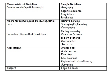
Spatial data handling involves many disciplines. We can distinguish disciplines that develop spatial concepts, provide means for capturing and processing of spatial data, provide a formal and theoretical foundation, are application-oriented, and support spatial data handling in legal and management aspects. The following Table shows a classification of some of these disciplines. They are grouped according to how they deal with spatial information. The list is not
meant to be exhaustive.
The discipline that deals with all aspects of spatial data handling is called Geoinformatics. It is defined as:
![]()
Geoinformatics has also been described as “the science and technology dealing with the structure and character of spatial information, its capture, its classification and qualification, its storage, processing, portrayal and dissemination, including the infrastructure necessary to secure optimal use of this information” (Groot, 1989). Ehlers and Amer (1991) define it as “the art, science or technology dealing with the acquisition, storage, processing production, presentation and dissemination of geoinformation.”
A related term that is sometimes used synonymously with geoinformatics is geomatics. It was originally introduced in Canada, and became very popular in French speaking countries. Laurini and Thompson (1992) describe it as “the fusion of ideas from geo-sciences and informatics.” The term geomatics, however, was never fully accepted in the United States where the term geographical information science is preferred. Goodchild (1992) defines GIS research as “research on the generic issues that surround the use of GIS technology, impede its successful implementation, or emerge from an understanding of its potential capabilities.”
There is no clear-cut definition for GIS. Different people defined GIS according to capability and purpose for which it is applied. Few of the definitions are:
- “A computer – assisted system for the capture, storage retrieval, analysis and display of spatial data, within a particular Organization” (Clarke, 1986).
- “A powerful set of tools for collecting, storing, retrieving at will, transforming and displaying spatial data from the real world” (Burrough, 1987).
- A GIS is defined as follows (Aronoff, 1989):
– A GIS is a computer-based system that provides the following four sets of capabilities to handle geo-referenced data:
– input,
– data management (data storage and retrieval),
– manipulation and analysis, and
– Output.
- “An internally referenced, automated, spatial information system” (Berry, 1986).
- “A system for capturing, storing, checking, manipulating, analyzing and displaying data which are spatially referenced to the Earth” (DOE, 1987:132)
- “An information technology which stores, analyses and display both spatial and non – spatial data”(Parker, 1988:1547)
- “A database system in which most of the data are spatially indexed, and upon which a set of procedures operated in order to answer queries about spatial entities in the database”(Smith, 1987:13)
- “An automated set of functions that provides professionals with advanced capabilities for the storage, retrieval, manipulation and display of geographically located data”(Ozemoy, Smith and Sicherman, 1981:92)
- “A decision support system involving the integration of spatially referenced data in a problem solving environment”(Cowen, 1988:1554)
- “A system with advanced geo – modeling capabilities”(Koshkariov, Tikunov and Trofimov, 1989:259)
Although the above definitions cover wide range of subjects and activities best refer to geographical information. Some times it is also termed as Spatial Information Systems as it deals with located data, for objects positioned in any space, not just geographical, a term for world space. Similarly, the term ‘a spatial data’ is often used as a synonym for attribute data (i. e. rainfall/ temperature/ soil chemical parameters/ population data etc.).
Frequently used technical terms in spatial data handling are:
Geographic (or geographical) Information System (GIS),
Geo-information System,
Spatial Information System (SIS),
Land Information System (LIS), and
Multi-purpose Cadastre.
Geographic information systems are used by various disciplines as tools for spatial data handling in a geoinformatics environment.
Depending on the interest of a particular application, a GIS can be considered to be a data store (application of a spatial database), a tool- (box), a technology, an information source or a science (spatial information science).
Like in any other discipline, the use of tools for problem solving is one thing; to produce these tools is something different. Not all are equally well suited for a particular application. Tools can be improved and perfected to better serve a particular need or application. The discipline that provides the background for the production of the tools in spatial data handling is spatial information theory (or SIT).
Geographic information technology is used to manipulate objects in geographic space, and to acquire knowledge from spatial facts. Spatial information theory provides a basis for GIS by bringing together fields that deal with spatial reasoning, the representation of space, and human understanding of space:
- Spatial reasoning addresses the inference of spatial information from spatial facts. It deals with the ramework and models for space and time, and the relationships that can be identified between objects in a spatio-temporal model of real world phenomena.
- Scientific methods for the representation of space are important for the development of data models and data structures to represent objects in spatial databases. Spatial databases are distinguished from standard databases by their capability to store and manage data with an extent in space and time (spatial data types).
- The human understanding of space, influenced by language and culture, plays an important role in how people design and use GIS.
The theory is used for the design of high-level models of spatial phenomena and processes. They are then mapped into conceptual, logical and physical models of spatial databases. The database stands central in the geoinformatics environment. It is the database that holds the data; without it, no useful function can be performed. Data are entered into the database in input processes. Later, they are extracted from the database for spatial analysis and display.
The processes of data management, analysis and display are often supported by rules that are derived from domain experts. Systems that apply stored rules to arrive at conclusions, are called rule-based or knowledge-based systems. Those that support decision making for space-related problems are known as spatial decision support systems (or SDSS). They are becoming increasingly popular in planning agencies and management of natural resources.
All these activities happen in a social, economic and legal context. It is generally referred to as spatial information infrastructure. Everything within this infrastructure and all concepts of space and time in turn are shaped and determined by the cultural background of the individuals and organizations involved.
3. HISTORY of GIS
The GIS history dates back 1960 where computer based GIS have been used and their manual procedures were in life 100 years earlier or so. The initial developments originated in North America with the organizations such as US Bureau of the Census, The US Geological Survey and The Harvard Laboratory for computer graphics and Environmental Systems Research Institute (commercial). Canadian Geographic Information Systems (CGIS) in Canada, Natural Experimental Research Center (NREC), Department of Environment (DOE) notable organizations in U.K. involved in early developments. The laboratory for Computer Graphics and Spatial Analysis of the Harvard Graduate School of Design or the State University of Newyork at Buffalo achieved worldwide recognition. Commercial agencies started to develop and offer GIS software. Among them was toady’s market leaders ESRI, Intergraph,
Laserscan and Autodesk etc.
A sound and stable data structures to store and analyze map data became dominant in the early 1970’s. This has lead to the introduction of topology into GIS. Topology and the related graph theory proved to be effective and efficient tools to provide logically consistent two-dimensional data representations. Another significant break through occurred with the introduction and spread of personal computers in 1980’s. It was possible to have a computer on the desk that was able to execute programs that previously could only be run on mainframe computers. At the same time minicomputers, and later, workstations became widely available. Relational database technology became the standard. Research on spatial data structures, indexing methods, and spatial databases made tremendous progress. The 1990’s can be characterized as a period of the breakthrough of object-orientation in system and database design, recognition of geoinformatics as a professional activity, and spatial information theory as the theoretical basis for GIS. Potentiality of GIS is realized in the recent fast and now it has become popular among many users for variety of applications
In India the major developments have happened for the last one-decade with significant contribution coming from Department of Space emphasizing the GIS applications for Natural Resources Management. Notable among them are Natural Resource Information System (NRIS), Integrated Mission for Sustainable Development (IMSD) and Bio-diversity Characterization at National Level. IIRS is also playing major role in GIS through education and training programs at the National and International level. Recently the commercial organizations in India have realized the importance of GIS for many applications like natural resource management, infrastructure development, facility management, business/market applications etc. and many GIS based projects according to the user organization requirements.
- GIS OBJECTIVES:
- Maximize the efficiency of planning and decision making
- Provide efficient means for data distribution and handling
- Elimination of redundant data base – minimize duplication
- Capacity to integrate information from many sources
- Complex analysis/query involving geographical referenced data to generate new information.
For any application there are five generic questions a GIS can answer:
- Location – What exists at a particular location?
- Condition – Identify locations where certain conditions exist.
- Trends – What has changed since?
- Patterns – What spatial pattern exists?
- Modeling – What if ………. ?
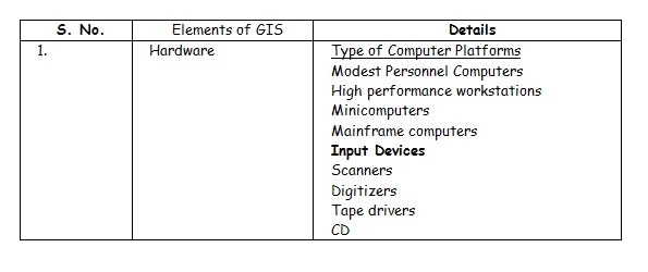
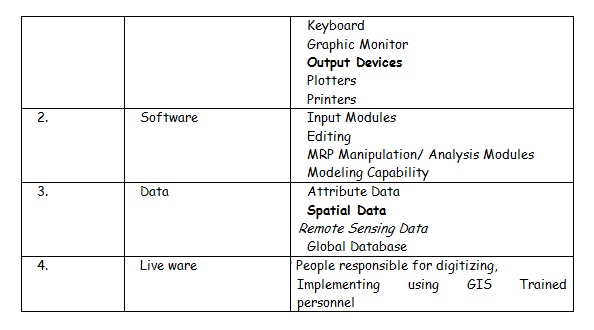
- Elements of a GIS:
The GIS has been divided into four elements. They are hardware, software, data, and liveware. The following table gives complete details of different elements: –
-
Data Models
Conversion of real world geographical variation into discrete objects is done through data models. It represents the linkage between the real world domain of geographic data and computer representation of these features. Data models discussed here are for representing the spatial information.
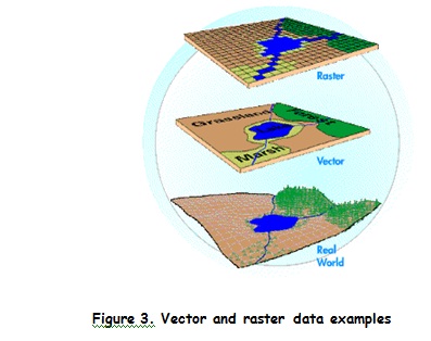
Data models are of two types: Raster and Vector. In raster type of representation of the geographical data, a set of cells located by coordinate is used; each cell is independently addressed with the value of an attribute. Each cell contains a single value and every location corresponds to a cell. One set of cell and associated value is a LAYER. Raster models are simple with which spatial analysis is easier and faster. Raster data models require a huge volume of data to be stored, fitness of data be limited by cell size & output is less beautiful. Figure 3 shows vector and raster data representation of the real world phenomena.
Vector data model uses line segments or points represented by their explicit x, y coordinates to identify locations. Connecting set of line segments forms area objects. Vector data models require less storage space, outputs are appreciable, Estimation of area/perimeter is accurate and editing is faster and convenient. Spatial analysis is difficult with respect to writing the software program.
The vector model is extremely useful for describing discrete features, but less useful for describing continuously varying features such as soil type or accessibility costs for hospitals. The raster model has evolved to model such continuous features. A raster image comprises a collection of grid cells rather like a scanned map or picture. Both the vector and raster models for storing geographic data have unique advantages and disadvantages. Modern GIS packages are able to handle both models.
Layers and Coverage’s
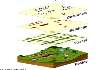
The common requirement to access data on the basis of one or more classes has resulted in several GIS employing organizational schemes in which all data of a particular level of classification, such as roads, rivers or vegetation types are grouped into so called layers or coverage’s. The concept of layers is to be found in both vector and raster models. The layers can be combined with each other in various ways to create new layers that are a function of the individual ones. The characteristic of each layer within a layer-based GIS is that all locations with each layer may be said to belong to a single Arial region or cell, whether it be a polygon bounded by lines in vector system, or a grid cell in a raster
System. But it is possible for each region to have multiple attributes. The following figure shows layers and coverage concept in GIs
DATA STRUCTURES
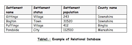
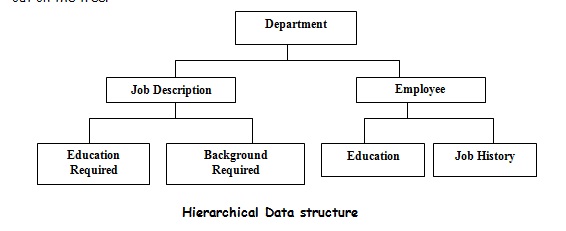
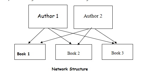
There are number of different ways to organize the data inside the information system. The choice of data structure affects both Data storage volume and processing efficiency. Many GIS software’s have specialized capabilities for storing and manipulating attribute data in addition to spatial information. Three basic data structures are – Relational, Hierarchical and Network.
Relational data structure organizes the data in terms of two-dimensional tables where each table is a separate file. Each row in the table is a record and each record has a set of attributes. Each column in the table is an attribute. Different tables are related through the use of a common identifier called KEY. Relation extracts the information, which are defined by query.
Hierarchical data structure stores the data in a way that a hierarchy is maintained among the data items. Each node can be divided into one or more additional node. Stored data gets more and more detailed as one branches further out on the tree
Network data structure is similar to hierarchy structure with the exception that in this structure a node may have more than one parent. Each node can be divided into one or more additional nodes. Nodes can have many parents. The network data structure has the limitation that the pointers must be updated everytime a change is made to database causing considerable overhead.
-
ERRORS IN GIS
Uncertainties and errors are intrinsic to spatial data and need to be addressed properly, not swept away the users by high quality colour outputs. Data accuracy is often grouped according to thematic accuracy, positional accuracy and temporal accuracy occurring at various stages in spatial data handling. Given below some of them while creating the spatial database and analysis.
(I) Errors in GIS environment can be classified into following major groups:
- Age of data – Reliability decreases with age
- Map scale – Non-availability of data are proper scale or
Use of data at different scales
- Density of observation – Sparsely dense data set is less reliable
- Relevance of data – Use of surrogate data leads to errors
- Data inaccuracy – Positional, elevation, minimum mapable unit etc.
- Inaccuracy of contents – Attributes are erroneously attached
(ii) Errors associated with processing
- Map digitization errors – due to boundary location problems on maps
and Errors associated with digital
representation of features
- Pasteurization errors – due to topological mismatch arising during
approximation by grid
- Spatial Integration errors- due to map integration resulting in spurious
polygons
- Generalization errors – due to aggregation process when features are
abstracted to lower scale
- Attribute mismatch errors
- Misuse of logic
The errors are also added from the source of data. Care must be taken to take care of creating spatial database from the accurate and reliable sources of data. Realizing the importance the users may demand in future to provide them the desired data with a tag that how much that the data is accurate, representing spatially in quantitative terms.
- Spatial Analysis
Whether it is effective utilization of natural resources or sustainable development, or natural disaster management, selecting best site for waste disposal, optimum route alignment or local problems have a geographical component; geoinformatics will give you power to create maps, integrate information, visualize scenarios, solve complicated problems, present powerful ideas, and develop effective solutions like never before. In brief it can be said as supporting tool for decision-making process. Map making and geographic analysis are not new, but a GIS performs these tasks better and faster than do the old manual methods. Today, GIS is a multibillion-dollar industry employing hundreds of thousands of people worldwide.
GIS is used to perform a variety of Spatial analysis, including overlaying combinations of features and recording resultant conditions, analyzing flows or other characteristics of networks; proximity analysis (i.e. buffet zoning) and defining districts in terms of spatial criteria. GIS can interrogate geographic features and retrieve associated attribute information, called identification. It can generate new set of maps by query and analysis. It also evolves new information by spatial operations. Following are the analytical procedures applied with a GIS. GIS operational procedure and analytical tasks that are particularly useful for spatial analysis include:
# Single layer operations
# Multi layer operations/ Topological overlay
# Geometric modeling
- Calculating the distance between geographic features
- Calculating area, length and perimeter
- Geometric buffers.
# Network analysis
# Surface analysis
# Raster/Grid analysis
There are many applications of Geoinformatics viz: facility management, planning, environmental monitoring, population census analysis, insurance assessment, and health service provision, hazard mapping and many other applications. The following list shows few applications in natural resource management:
- Agricultural development
- Land evaluation analysis
- Change detection of vegetated areas
- Analysis of deforestation and associated environmental hazards
- Monitoring vegetation health
- Mapping percentage vegetation cover for the management of land
- Crop acreage and production estimation
- Wasteland mapping
- Soil resources mapping
- Groundwater potential mapping
- Geological and mineral exploration
- Snow-melt run-off forecasting
- Monitoring forest fire
- Monitoring ocean productivity etc.
- GIS application in Forestry
With the rise of World Wide Web, new Internet protocols such as the hypertext Transfer Protocol (HTTP), as well as easy to use interfaces (browsers), tools and languages (HTML, XML, and Java), the Internet has become hub for GIS functionalities from the client side with out even any GIS software. The GIS field is still evolving and it will be the major force in various walks of life dealing with geographic information.
REFERENCES
- “Principles of Geographical Information Systems for Land Resource Assessment” by P.A.Burrough.
- “Geographical Information Systems –Principles” Vol.1 by Goodchild.
- International Journal of Geographical Information Science.
- Geocarto International – A GIS Journal
- GIS Asia Pacific – The Geographic Technology Publication for the Asia Pacific Region (geoplace.com)
Web site references:
- GIS education in schools
http://www.ncgia.ucsb.edu/~spalladi/thesis/Chapter3.html
- Self learning with interactive examples
http://www.sli.unimelb.edu.au/gisweb/menu.html
- link website for GIS sites
http://www.gislinx.com/Software/Programs/MicroStation/index.shtml
- http://geog.hkbu.edu.hk/geog3600/ (Hongkong Baptist University)
- ppt slides on trends
http://geosun.sjsu.edu/paula/137/ppt/lecture13/sld008.htm
- Canadian Remote sensing tutorial
http://www.ccrs.nrcan.gc.ca/ccrs/eduref/tutorial/tutore.html
- GIS short course handouts and ppt files on GIS,GPS and OO Programming
http://www.cla.sc.edu/gis/avshtcrs/handouts.html
- GIS @ Development (www.gisdevelopment.net)
- GIS India – A bimonthly GIS Journal
- http://www.nasa.org
- http://www.planweb.co.uk/
- http://www.sbg.ac.at/geo/idrisi/wwwtutor/tuthome.htm
- http://www.ed.ac.uk/
- http://www.geoplace.com


آخرین نظرات